-
North and Central America
Can't find your location? Visit our global site in English.
-
South America
Can't find your location? Visit our global site in English.
- Asia
-
Oceania
Can't find your location? Visit our global site in English.
-
Europe
- Austria - Deutsch
- Belgium - English Français
- Czech Republic - Česky
- Finland - Suomalainen
- France - Français
- Germany - Deutsch
- Italy - Italiano
- Netherlands - Nederlands
- Poland - Polski
- Portugal - Português
- Romania - Română
- Spain - Español
- Switzerland - Deutsch Français Italiano
- Sweden - Svenska
- Turkey - Türkçe
- United Kingdom - English
- Kazakhstan - Русский
- Africa and Middle East

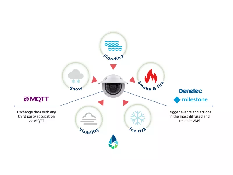
Axis and WaterView deliver advanced weather and environmental analytics for smart spaces and infrastructure management. Combining Axis’s premium technology with WaterView’s hazard detection, the solution integrates seamlessly into CCTV networks, providing real-time alerts for risks like heavy precipitation, flooding and wildfires. Ideal for cities, transportation, and utilities, it ensures rapid response and operational safety.
How it works?
WaterView offers five AI-driven ACAP applications for Axis cameras to monitor weather and environmental conditions:
- floodCAM, to identify flooded areas and water level changes in water bodies
- snowCAM, to spot snow covered areas
- smoCAM, for identifying smoke plumes and fires in both outdoor and indoor environment
- visCAM, to estimate the visibility distance
- weatherCAM, to identify precipitation (rainfall, snowfall) and estimate their severity
These solutions integrate seamlessly with Axis cameras via Axis OS, triggering actions like email alerts, video recording, and VMS integration. Fully compatible with Artpec-7 and 8 cameras, they require no additional hardware, delivering tailored monitoring for diverse infrastructure needs.
Why Axis and WaterView?
Use cases
Explore WaterView and Axis solutionsFlooded areas on urban roads
WaterView uses floodCAM on Axis cameras to draw a control area on the road surface to trigger an alert when the detected water surface is larger than a threshold percentage of the control area. Detecting flooded areas on urban roads is helpful in traffic and driving safety.
Water levels in rivers, creeks and channels
Detect changes of water level in rivers, creeks and channels with WaterView floodCAM on an Axis camera. Draw some stacked control areas on the river bank (or on another vertical surface), and set a threshold for each control area, to be notified when the water level gradually rises above multiple safety values.
Warnings for wildfires
WaterView uses smoCAM to send early warnings for wildfires that may put natural areas at risk. Install a network of Axis cameras equipped with smoCAM, set one or more control areas for each camera view, and set rules to send images or messages whenever a smoke plume or a flame is detected inside a control area.
Low visibility along road networks
WaterView detect low visibility areas along road networks, to promptly notify drivers on the go via variable message panels. Use Axis cameras along the road to continuously estimate the visibility distance, and set a minimum value to trigger automatic updates of warnings displayed by variable message panels


