


Waterways of greater Toulon Provence Méditerranée under surveillance by Axis cameras
Analysis and image processing provides waterway data for efficient flooding prevention.
Mission
After recent floods, when streams and waterways breached their banks, prevention has become a priority for the community and a challenge for protecting the populace. Metropolitan Toulon Provence Méditerranée, along with local public safety authorities and the river guilds, is committed to improving knowledge and awareness of flood risks by providing prevention and warning tools.
Solution
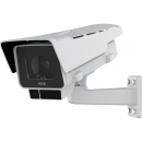
Since 2017, the region has had a real-time information system for monitoring the waterways with cameras at the region’s main watersheds. This surveillance system has been implemented by Automatic Alarm and TENEVIA (the TENEVIA CamFlow® solution) at five sites from AXIS P1367-E Network Cameras. The patented TENEVIA CamFlow® technology is based on analysis and image processing software that digitizes water surfaces to obtain hydrometric data, even at night, thanks to infrared projectors slaved to the cameras. All this allows data analysis in real time over the Internet.
Result
In this way, TENEVIA and Axis make it easy for metropolitan and community agents in charge of flood monitoring to understand the hydrological situation. The tool is easy to access and read. It measures waterway data for water levels and flows and triggers an alert when the thresholds are exceeded. This support allows true surveillance of waterways in real time and allows public safety authorities to take action when a risk is detected. Further development could include expanding the system by integrating additional data, such as weather forecasts and direct communication from professional mobile devices, says Géraldine Crespin.
The continuous improvement of Axis equipment performance now allows hydrometric measures by high-quality cameras while developing additional functionalities, such as detection of logjams and water pollution.

Flood monitoring for public safety
Greater Toulon Provence Méditerranée consists of 12 communities and is crossed by numerous small coastal rivers in heavily urbanized areas. Over time, the morphology of these waterways has evolved, as have development and land use planning. After recent flooding, when streams and waterways breached their banks, preventing floods has become a priority for the community and a challenge for prevention and for protection of the populace. Metropolitan Toulon Provence Méditerranée, along with local public safety authorities and the river guilds is committed to improving knowledge and awareness of flood risks by providing prevention and warning tools.
Also, since 2017, the region has had a real-time information system for monitoring the waterways with cameras at the region’s main watersheds. The contract was won and the project implemented by Automatic Alarm and TENEVIA, currently at five sites.
These cameras are linked directly to the TPM security center by fiber optics deployed in the region by the metropolitan authority. The agents in charge of safety for each community can therefore visualize in real time the changes in each waterway and easily confirm the warnings issued by each camera. Measurements of water levels, speeds and flows are made by the TENEVIA CamFlow® solution using AXIS P1367-E Network Cameras.

Waterways engulfed by solutions
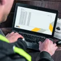
The patented TENEVIA CamFlow® technology is based on analysis and image processing software that digitizes water surfaces to obtain hydrometric data. The system’s nocturnal operation relies on infrared projectors connected to the cameras. But this system does more than that, offering concrete solutions — in fact the data obtained from image processing are accessible in real time through a web browser.
In this way, TENEVIA and Axis make it easy for metropolitan and community agents in charge of flood monitoring to understand the hydrological situation. Furthermore, within the Program for Action and Flood Prevention approved on July 5, 2018, by the Joint Flood Commission, the measurement data will be provided to the Flood Forecasting Commission in charge of monitoring and providing information on floods to allow alert maps to be created for the upcoming 24 hours. This will complement the hydrometric data issued by the measuring stations or the gauging done by VIGICRUES networks hydrometers.

“Integration and handling of the system by different users is no problem. The tool is easy to access and read. It measures waterway data for water levels and flows and triggers an alert when the thresholds are exceeded. It is an excellent aid that allows us accurate surveillance of waterways in real time and allows public safety authorities to take action when a risk is detected. Now we hope to have the system expanded by integrating additional data, such as weather forecasts and direct communication from professional mobile devices,” says Géraldine Crespin, head of the department of natural and urban spaces in charge of natural risks for the Toulon Provence Méditerranée metropolitan area.
Products & solutions